 BY PERRY THORVIG
Over the last 20 years, Southsiders have seen the massive rebuilding of the Hiawatha corridor. New apartment buildings have been appropriately located along the light rail corridor. Mixed use in the form of a major brand grocery store has also been included in the rebuild of one of the parcels.
Southsiders are also seeing the first examples of what the City Council’s 2040 Plan has in store for other major streets on the Southside and in other parts of the city, as well. For example, the two five-story apartment buildings on the 4200 block of Nicollet Avenue are way out of scale with their surroundings. They are much taller and have more square footage than the stately, older two-and-a-half story apartment buildings on the block, not to mention the single-family homes.
Is this the kind of development that you want to see in your neighborhood, or next door?
This year is the 100th anniversary of zoning controls in Minneapolis. Since 1924, Minneapolis has not allowed the free market to determine what is built in the city and how tall buildings will be. However, there were elements of the free-market system contained in the city’s 1924 zoning code. For example, it allowed commercial or industrial uses on most of the arterial streets on the Southside. That code also allowed single-family homes and apartment buildings to be built in commercial or industrial zones. What resulted was mostly single-family or apartment development on the main streets. The blocks between the major streets were reserved for single or two-family dwellings in the 1924 code.
There were some problems with the 1924 code. The City Council tried for 39 years to change the ordinance to address problems with their first zoning code. Finally, in 1963, there was a major revision that limited neighborhood-scale commercial development to designated major intersections in the city. However, the interior of the Southside neighborhoods down to 36th Street was still zoned for high-density development in order to meet projected population growth that never occurred. The city reached its highest population in 1950.
The 1963 zoning code resulted in the demolition of numerous single and two-family homes so that large two-and-a-half story apartment buildings could be built. For the next 30 years Minneapolis lost population while homes were removed in favor of apartment buildings on the near Southside.
Residents between Franklin Avenue and 36th Street became increasingly concerned about all the new apartment buildings that were changing the character of their neighborhoods. Their organized neighborhood groups asked for zoning changes to preserve existing homes with affordable rents. They found a sympathetic ear in the Minneapolis planning department. Studies were undertaken to downzone (reduce allowable density) residential streets on the near Southside and Northside neighborhoods.
The new zoning controls adopted by the City Council in the mid-1970s required rezoning by a developer or a conditional use permit in order to develop new apartment buildings. It guaranteed that adjacent residents would be informed and have an opportunity to oppose or support the development. Prior to that, the 1963 code allowed apartment buildings without any public hearings.
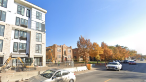
New construction such as this multi-unit building at 42nd and Nicollet dwarfs existing residential buildings.
That brings us to the 2040 Plan. That plan is based on the idea that more density is needed to accommodate people who want to live in the city. It’s important to point out that there were approximately 40,000 more housing units in Minneapolis in 2022 than in 1950 with about 90,000 fewer people in 2022 compared to 1950. Family size is much smaller now than in 1950.
The 2040 Plan’s policies and land use designations will allow the same kind of development seen in the 4200 block of Nicollet virtually everywhere there are single-family homes on arterial streets. What’s more, up to three-unit buildings could be built anywhere there is single-family zoning. The environmental impacts – traffic, noise, water and sewer use, school population, etc. – of this kind of development have not been quantified. The City Council, city planners, and Minneapolis residents do not know exactly what the impacts of the 2040 Plan will be. That is the basis of the current lawsuit against the City of Minneapolis.
Apparently, the city does not want to do the environmental analysis. So they concocted a bill for the Minnesota legislature to consider that would preempt environmental review of comprehensive plans. There was not time to consider this bill last year. Look for it to surface again in this legislative session. In the meantime, another bill has been introduced to require all municipalities with more than 5,000 people to allow two-family dwellings in any single-family zoning category.
So, be vigilant. Watch what your council members and legislators are doing. Your future and your neighborhood‘s future depend on it.
Perry Thorvig was a Minneapolis city planner from 1968-1997.