1854
Township 28N, Range 24W, Hennepin County, Minnesota. Note the wetlands on both sides of the Creek and at the west side of Rice Lake. The blank southeast corner is part of the Fort Snelling Military Reservation. The curlicue representation of the Creek is typical of older maps.
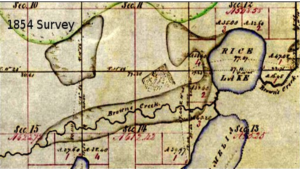
The town of Minneapolis was recognized by the legislature in 1856. The City of Minneapolis incorporated in 1867.
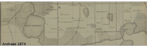
1874
The shaded areas represent wetlands which extended, almost uninterrupted, from Lake Harriet east to 28th Avenue. Not shown: the wetlands follow the creek throughout Minnehaha Falls Park and along the Mississippi River. The southern border of Minneapolis was primarily along 24th Street in 1874.
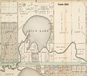
1892
This 1892 map illustrates that urbanization was rapidly overtaking the Rice Lake/Lake Amelia (Hiawatha-Nokomis) area. Speculators and developers had largely replaced the small farmers and other small businesses on the former 40-80 acre parcels. By this time, the southern boundary of the City of Minneapolis was 54th Street.
Northeast of Rice Lake, Lot 2 – shown here subdivided into large lots for residential development – was once part of the dairy farm operated by Esther Osmer. Residences (cottages?) with outbuildings had concentrated on the east side of Rice Lake south to Minnehaha Parkway. The platted blocks were almost entirely vacant lots.
The dotted lines in Lake Nokomis (partially shown) and Rice Lake along with the Creek east of Cedar Avenue were formerly the boundaries of the Fort Snelling Military Reservation.
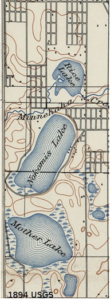
1894
This 1894 topographical map by the U.S. Geographical Survey does not show wetlands at Rice Lake or adjacent areas of Minnehaha Creek. However, areas in Lake Hiawatha Park and along Minnehaha Parkway between Hiawatha and the Falls were referred to by the Park Board as swamp lands until at least 1933.
Wetlands remained at the southwest corner of Lake Nokomis and around most of Mother Lake.
Timeline Notes
- In 1906, Theodore Wirth went to work for the Minneapolis Park Board .
- In 1922, the Minneapolis Park Board paid $555,000 for Lake Hiawatha The park contained about 40 buildings.
- In 1929, the Park Board budget for Lake Hiawatha Park improvements was $237,000. Of this,
$66,400 came from the rental and sale of the buildings and $10,000 was City bonds to be paid for by golf course revenues.
- By 1933, improvements to Lake Hiawatha and the Creek from the lake east to the falls were 75% complete. The improvements featured “an 18-hole golf course, a well-equipped playground, a bathing beach, 20 concrete tennis courts, and three modern service ”
Shawne FitzGerald
March 2022
————————————————-
Sources
Andreas, A. T. Plan of the City of Minneapolis and vicinity, with Minnehaha Falls. 1874. [Map image]. In David Rumsey Historical Map Collection. Available online.
Interview with Kathryn Kelly, Save Hiawatha 18, re: Lake Hiawatha area land ownership ca. 1870-1920. March 7, 2022. Inventory Table of Park Properties-Period of Board’s Existence, Retrospective Sketch of the First Half-century of
Minneapolis Park Development Under the Board of Park Commissioners, 1883-1933. [Ebook] The Minneapolis Park Board of Commissioners. 1933. Available online.
Hennepin County Library James K. Hosmer Special Collections staff. Minneapolis: 150 Years of Growth [map image].
- In Growth of Minneapolis, Hennepin County Tumblr, ca. 2012. Available online.
Jarrett, J. T. Original Survey MN 4th PM – 1831 MN/WI Township 028.0N Range 024.0W Subdivisional Meanders. [Map image] 1854. U.S. Department of the Interior Bureau of Land Management General Land Office Records. Available online.
Plate 51. [Map image] Atlas of the City of Minneapolis, Minnesota. C. M. Foote & Co. 1892. University of Minnesota John R. Borchert Map Library Plat Maps and Atlases Collection. Available online.
U.S. Department of the Interior Geological Survey. Saint Paul, U. S. Geological Survey Topographic Sheet [Map image]. 1894. University of Texas Perry-Castañeda Library Map Collection. Available online.
Wikipedia contributors. History of Minneapolis. 2022, January 17. In Wikipedia, The Free Encyclopedia. Available online.
Inventory Table of Park Properties-Period of Board’s Existence, Retrospective Sketch of the First Half-century of Minneapolis Park Development Under the Board of Park Commissioners, 1883-1933. [Ebook] The Minneapolis Park Board of Commissioners. 1933. Available online.